Page 69 of 69
Re: It's getting warm
Posted: Thu May 28, 2026 10:50 am
by donlever
I see what u did there...
Re: It's getting warm
Posted: Thu May 28, 2026 12:45 pm
by Meds
Topper wrote: ↑Thu May 28, 2026 6:47 am
They were transported to their current location between 90 and 50 million years ago. Much of BC was the latitude of Mexico (tectonics folks call it Baja BC).
Would that result in the rocks in Mexico being from somewhere else then as well? Or does that relocation result in drops of elevation?
Re: It's getting warm
Posted: Thu May 28, 2026 2:03 pm
by Topper
I had a long answer typed and my session crapped out and I lost the post
so listen to Nick Zentner
Nick is preaching the work of Bob Hildebrand, an Arizona geo. Many of the BC geo's disagree on the fault under the Rockies saying it is contrary to most of their field work. One BC geo working with a geophysicist in France it putting together the idea that the fault is further west through central BC.
Re: It's getting warm
Posted: Thu May 28, 2026 4:25 pm
by Topper
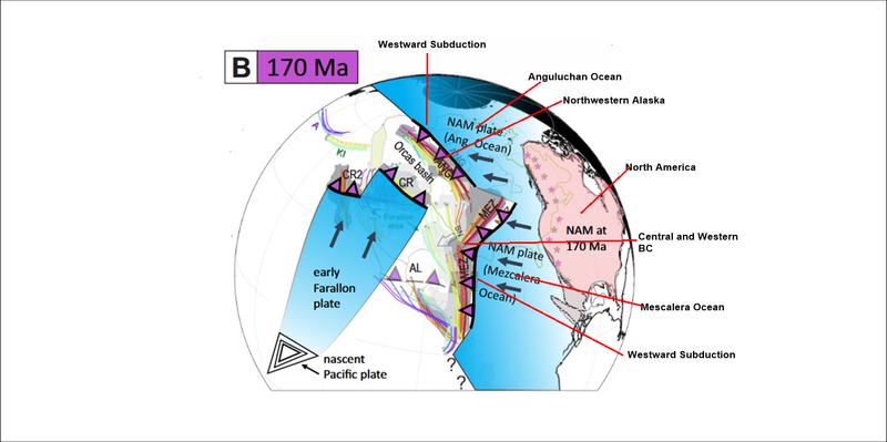
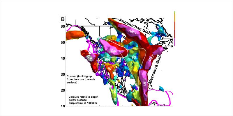
170 million years ago, North America is heading westward, pushed by the opening of the Atlanic and the mid Atlanic spreading ridge. The Angyluchan and Mescaleran oceans (prto - Pacific) are closing to the west as their underlying ocianic rocks are subducted into a trench. Volcanism on the west side of the trench forms the Insular Belt (much of western BC) and the Angyluchan Arc (northwestern Alaska).
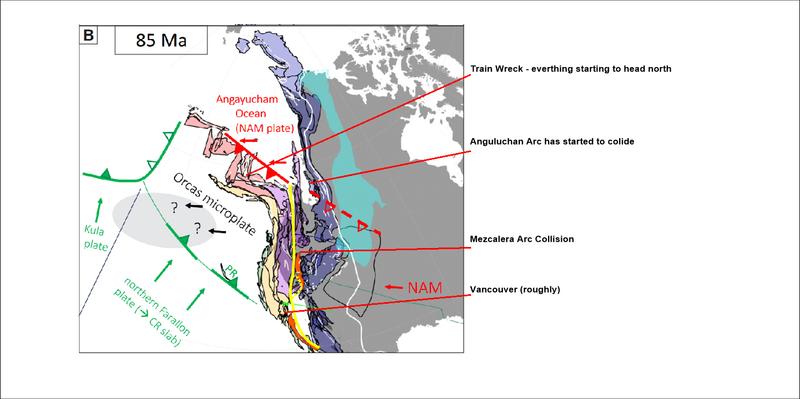
 85 million years ago
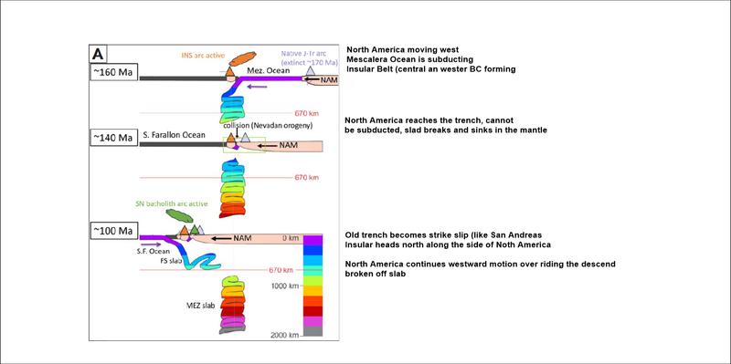
, North America has closed the Mescalera Trench and is closing the Angyluchan Trench. The continental rocks are bouyant and can not be subducted. The descending slab breaks off and continues to sink in the mantle. Free of the descending slab, motion on the trench (fault) becomes strike slip and the Insular belt and Angyluchan arc head north (similar to present day motion on the San Andreas)
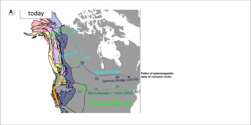
 0 million years ago
, current scenario, an offshore eastern dipping subduction event is near concluding North America has continued west over riding the broken slabs of the Mezcaleran and Angyluchan Arcs that currently rest vertically in the mantle below the eastern seaboard.
In cross section, a cartoon of the above
A geologist from the BC Geological Survey has been working with a geophysicist on the University Cote d Azur who has modeled the mantle using seismic waves. As more geoprobe stations become available the modelling improves. Currently resolution of the data becomes messy over 1800 kilometres depth in the mantle. I stole the images from a preprint of their most recent paper.(Karin Sigloch & Mitchell G. Mihalynuk)
The question is, where is that fault that all that strike slip movement occurred on. Bob Hildebrand, from Arizona believes it is under the Rockies. Mitch and Karin are currently working on their idea that it is in central BC. The central BC narrative fits better with BC Geological Survey field mapping.
Re: It's getting warm
Posted: Fri May 29, 2026 6:29 am
by Cousin Strawberry
What trips a dude right the fuck out is that all life is merely a little tuft of blue, green and brown riding around on rafts of rock floating on an eternal sea of lava
Re: It's getting warm
Posted: Fri May 29, 2026 8:35 am
by Tciso
Cousin Strawberry wrote: ↑Fri May 29, 2026 6:29 am
What trips a dude right the fuck out is that all life is merely a little tuft of blue, green and brown riding around on rafts of rock floating on an eternal sea of lava, all working together to keep the Canucks from ever winning a Cup

Re: It's getting warm
Posted: Fri May 29, 2026 7:49 pm
by Topper
I recall in school, before 3D and 4D computer simulations, the guys working on this did a lot of acid and were a reliably supply for us less frequent fliers