
It's getting warm
Moderators: donlever, Referees
-
donlever

- Moderator & MVP

- Posts: 7217
- Joined: Tue Feb 28, 2012 2:07 pm
-
Meds

- MVP
- Posts: 6269
- Joined: Mon Jul 11, 2011 8:50 pm
Re: It's getting warm
Would that result in the rocks in Mexico being from somewhere else then as well? Or does that relocation result in drops of elevation?
Somewhere in NW BC trying (yet again) to trade a(nother) Swede…..
-
Topper

- CC Legend
- Posts: 8717
- Joined: Wed Sep 15, 2004 8:11 pm
- Location: Earth, most days.
Re: It's getting warm
I had a long answer typed and my session crapped out and I lost the post
so listen to Nick Zentner
Nick is preaching the work of Bob Hildebrand, an Arizona geo. Many of the BC geo's disagree on the fault under the Rockies saying it is contrary to most of their field work. One BC geo working with a geophysicist in France it putting together the idea that the fault is further west through central BC.
so listen to Nick Zentner
Nick is preaching the work of Bob Hildebrand, an Arizona geo. Many of the BC geo's disagree on the fault under the Rockies saying it is contrary to most of their field work. One BC geo working with a geophysicist in France it putting together the idea that the fault is further west through central BC.
Over the Internet, you can pretend to be anyone or anything.
I'm amazed that so many people choose to be complete twats.
I'm amazed that so many people choose to be complete twats.
-
Topper
- CC Legend
- Posts: 8717
- Joined: Wed Sep 15, 2004 8:11 pm
- Location: Earth, most days.
Re: It's getting warm
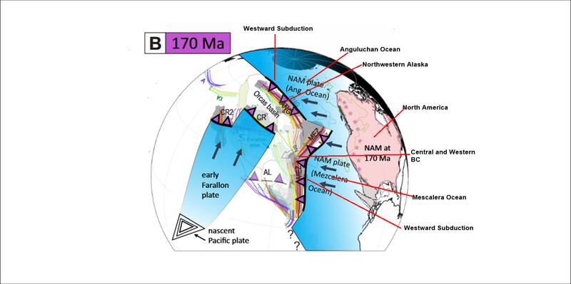
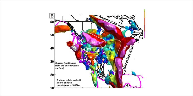
170 million years ago, North America is heading westward, pushed by the opening of the Atlanic and the mid Atlanic spreading ridge. The Angyluchan and Mescaleran oceans (prto - Pacific) are closing to the west as their underlying ocianic rocks are subducted into a trench. Volcanism on the west side of the trench forms the Insular Belt (much of western BC) and the Angyluchan Arc (northwestern Alaska).
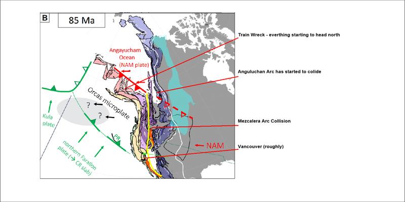
85 million years ago, North America has closed the Mescalera Trench and is closing the Angyluchan Trench. The continental rocks are bouyant and can not be subducted. The descending slab breaks off and continues to sink in the mantle. Free of the descending slab, motion on the trench (fault) becomes strike slip and the Insular belt and Angyluchan arc head north (similar to present day motion on the San Andreas)
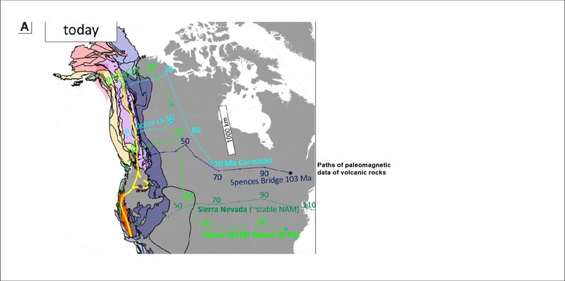
0 million years ago, current scenario, an offshore eastern dipping subduction event is near concluding North America has continued west over riding the broken slabs of the Mezcaleran and Angyluchan Arcs that currently rest vertically in the mantle below the eastern seaboard.
In cross section, a cartoon of the above
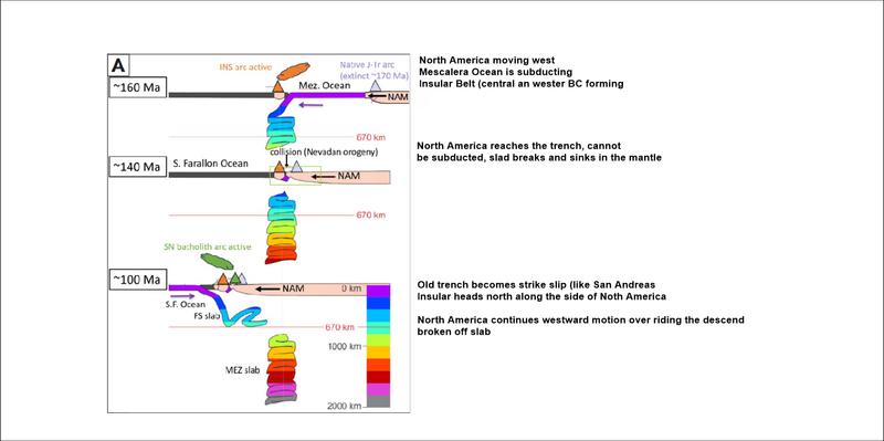
A geologist from the BC Geological Survey has been working with a geophysicist on the University Cote d Azur who has modeled the mantle using seismic waves. As more geoprobe stations become available the modelling improves. Currently resolution of the data becomes messy over 1800 kilometres depth in the mantle. I stole the images from a preprint of their most recent paper.(Karin Sigloch & Mitchell G. Mihalynuk)
The question is, where is that fault that all that strike slip movement occurred on. Bob Hildebrand, from Arizona believes it is under the Rockies. Mitch and Karin are currently working on their idea that it is in central BC. The central BC narrative fits better with BC Geological Survey field mapping.
85 million years ago, North America has closed the Mescalera Trench and is closing the Angyluchan Trench. The continental rocks are bouyant and can not be subducted. The descending slab breaks off and continues to sink in the mantle. Free of the descending slab, motion on the trench (fault) becomes strike slip and the Insular belt and Angyluchan arc head north (similar to present day motion on the San Andreas)
0 million years ago, current scenario, an offshore eastern dipping subduction event is near concluding North America has continued west over riding the broken slabs of the Mezcaleran and Angyluchan Arcs that currently rest vertically in the mantle below the eastern seaboard.
In cross section, a cartoon of the above
A geologist from the BC Geological Survey has been working with a geophysicist on the University Cote d Azur who has modeled the mantle using seismic waves. As more geoprobe stations become available the modelling improves. Currently resolution of the data becomes messy over 1800 kilometres depth in the mantle. I stole the images from a preprint of their most recent paper.(Karin Sigloch & Mitchell G. Mihalynuk)
The question is, where is that fault that all that strike slip movement occurred on. Bob Hildebrand, from Arizona believes it is under the Rockies. Mitch and Karin are currently working on their idea that it is in central BC. The central BC narrative fits better with BC Geological Survey field mapping.
Over the Internet, you can pretend to be anyone or anything.
I'm amazed that so many people choose to be complete twats.
I'm amazed that so many people choose to be complete twats.
-
Cousin Strawberry

- MVP
- Posts: 9984
- Joined: Sat Jul 09, 2011 10:19 pm
- Location: in the shed with a fresh packed bowl
Re: It's getting warm
What trips a dude right the fuck out is that all life is merely a little tuft of blue, green and brown riding around on rafts of rock floating on an eternal sea of lava
If you need air...call it in
-
Tciso

- MVP
- Posts: 1776
- Joined: Thu Sep 25, 2008 9:44 am
Re: It's getting warm
Cousin Strawberry wrote: ↑Fri May 29, 2026 6:29 am What trips a dude right the fuck out is that all life is merely a little tuft of blue, green and brown riding around on rafts of rock floating on an eternal sea of lava, all working together to keep the Canucks from ever winning a Cup

The Cup is soooooo ours!!!!!!!
-
Topper
- CC Legend
- Posts: 8717
- Joined: Wed Sep 15, 2004 8:11 pm
- Location: Earth, most days.
Re: It's getting warm
I recall in school, before 3D and 4D computer simulations, the guys working on this did a lot of acid and were a reliably supply for us less frequent fliers
Over the Internet, you can pretend to be anyone or anything.
I'm amazed that so many people choose to be complete twats.
I'm amazed that so many people choose to be complete twats.
-
Per

- MVP
- Posts: 4654
- Joined: Fri Jul 15, 2011 7:45 am
- Location: Sweden
Re: It's getting warm
Lots of forest fires in Spain, France and Italy as they suffer their third heat wave in six weeks.
I have ordered an AC that will be installed some time next week.
Traditionally we haven’t really needed AC in Sweden, but the summers keep getting hotter.
I have ordered an AC that will be installed some time next week.
Traditionally we haven’t really needed AC in Sweden, but the summers keep getting hotter.
Be Good
I like my whisky neat, so fuck ICE
I like my whisky neat, so fuck ICE
-
Per
- MVP
- Posts: 4654
- Joined: Fri Jul 15, 2011 7:45 am
- Location: Sweden
Re: It's getting warm
Worst fire in Norwegian history.
More than 100 homes burnt to the ground in Drammen.
The fire spread very quickly because the surroundings were very dry due to the recent heat wave.
https://www.bbc.com/news/videos/c4gj5944n4ko
More than 100 homes burnt to the ground in Drammen.
The fire spread very quickly because the surroundings were very dry due to the recent heat wave.
https://www.bbc.com/news/videos/c4gj5944n4ko
Be Good
I like my whisky neat, so fuck ICE
I like my whisky neat, so fuck ICE
-
donlever
- Moderator & MVP
- Posts: 7217
- Joined: Tue Feb 28, 2012 2:07 pm
Re: It's getting warm
It's over Per....enjoy your life man...you're not stopping it bud....
DeLevering since 1999.
-
Per
- MVP
- Posts: 4654
- Joined: Fri Jul 15, 2011 7:45 am
- Location: Sweden
Re: It's getting warm
Agreed. It will take decades - or generations - to reverse this. If possible at all.
It will keep getting warmer for the rest of my life. But at least I’ve got AC installed now.
Just have to keep my fingers crossed I can stay clear of catastrophic weather events.
One pressing concern right now is that the hops harvests in Czechia are dwindling. It is getting too hot for the traditional hops varieties.
Imagine if the crisp taste of a traditional Czech pilsner is lost for future generations!

Be Good
I like my whisky neat, so fuck ICE
I like my whisky neat, so fuck ICE
-
Topper
- CC Legend
- Posts: 8717
- Joined: Wed Sep 15, 2004 8:11 pm
- Location: Earth, most days.
Re: It's getting warm
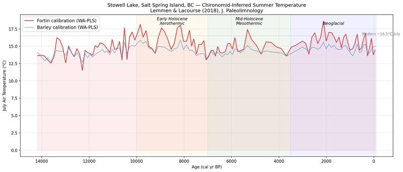
15,000 years of Salt Spring Island
Over the Internet, you can pretend to be anyone or anything.
I'm amazed that so many people choose to be complete twats.
I'm amazed that so many people choose to be complete twats.
-
Meds
- MVP
- Posts: 6269
- Joined: Mon Jul 11, 2011 8:50 pm
Re: It's getting warm
If I’m reading that correctly it’s been remarkable consistent in its fluctuations with only one alarming peak in the past 4000 years…..and contrary to the global warming doomsayers we are actually on the lower end of the spectrum right now but I’m guessing on a 50-100 year climb.
The many peaks and valleys of that graph also seem to prove climate change is merely climate flux that has been happening regardless of civilization or global population.
The many peaks and valleys of that graph also seem to prove climate change is merely climate flux that has been happening regardless of civilization or global population.
Somewhere in NW BC trying (yet again) to trade a(nother) Swede…..
-
Cousin Strawberry
- MVP
- Posts: 9984
- Joined: Sat Jul 09, 2011 10:19 pm
- Location: in the shed with a fresh packed bowl
Re: It's getting warm
Doesn't the ocean serve as a thermal battery of sorts? Regulating extreme temperature swings more than areas without?
If you need air...call it in
-
Per
- MVP
- Posts: 4654
- Joined: Fri Jul 15, 2011 7:45 am
- Location: Sweden
Re: It's getting warm
The climate has been remarkably consistent since the last ice age. That is supposed to be the reason why there have been homo sapiens around for almost 300,000 years but civilisation and agriculture only during the last 12,000 years. Before the end of the last ice age the climate was too volatile to make agriculture make sense, and with constantly changing climates and sea levels, the nomadic life style was the only sensible option. You had to be able to pack up and leave at short notice and go where the best chances of finding food would be over the next period of time.Mëds wrote: ↑Mon Jul 20, 2026 7:19 pm If I’m reading that correctly it’s been remarkable consistent in its fluctuations with only one alarming peak in the past 4000 years…..and contrary to the global warming doomsayers we are actually on the lower end of the spectrum right now but I’m guessing on a 50-100 year climb.
The many peaks and valleys of that graph also seem to prove climate change is merely climate flux that has been happening regardless of civilization or global population.
What climate scientists worry about is that with the rapid rise of temperature in recent decades we may be moving away from that stability.
And yeah, global temperatures have risen. This graph is from one specific island. The climate change is not happening at the same speed everywhere. Temperatures are actually rising faster in Scandinavia then the global average. Maybe that's why people here seem to be more concerned.
I'm trying to adapt, have planted grapes and a peach tree and last week I had AC installed.
That hasn't really been needed in Sweden traditionally, but every summer seems to get a little hotter than the last one.
Be Good
I like my whisky neat, so fuck ICE
I like my whisky neat, so fuck ICE